Innovations in acquisition geometries, telemetry improve complex imaging, seismic logging
COIL SHOOTING GEOMETRY
WesternGeco has developed a new single-vessel method of acquiring seismic data over a wide range of azimuths that the organization says improves the efficiency of the complex imaging process, especially on smaller exploration fields.
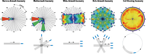
Comparison of acquisition geometries (bottom figures) and azimuth-offset distribution plots in rose diagrams (top figures).
Development of this new method, called coiled shooting, began when it was discovered during wide-azimuth (WAZ) surveys that vessels could produce useful seismic data during the semi-circle course change after each pass over the target. Building on this realization, the organization was able to develop a new survey geometry in which the area is covered in overlapping circles, 5-7 km in radius, in a corkscrew pattern.
The concept of a circular survey is not new, having been tried in the 1980s for improving imaging around salt domes. The approach was abandoned because technology at the time didn’t allow for accurate streamer positioning and steering.
Finally, in 2006, it became possible to use circular surveys for 3D full-azimuth acquisition due to the advent of the company’s Q-Marine technology. Rob Ross, marine marketing manager with WesternGeco, explained that as the vessel goes around the circle, there’s an increased risk of the streamers coming together and tangling. “But the Q-Fin is an extremely powerful tool we have for keeping the streamers evenly separated by having lateral control on their positioning,” he explained.
To achieve streamer positioning, the Q-Fins are incorporated at 400-m intervals along the streamer. It allows lateral and vertical motion of hydrophones to be precisely controlled along the entire length of the streamer. Each Q-Fin is a 1-m long streamer section that allows mounting of two independently movable wings, with servo-motors, sensors and micro-controller.
The individual location of each hydrophone is monitored by intrinsic ranging by modulated acoustics (IRMA). The system uses seismic hydrophones in active sections for streamer positioning on Q-Marine vessels. It works between a 0.5 – 4 KHz bandwidth and therefore does not affect seismic data collection.
 3D prestack depth migration of full aperture, full fold parallel wide-azimuth survey (left) and coil shooting test data (right). The coil shooting data exhibits indications of improved imaging, such as higher amplitude and better continuity of the salt overhang in the top-left area of the section.
Certainly, one key benefit of coil shooting is that it requires only one recording vessel. WAZ surveys, which are already commonly used to obtain clearer seismic images from beneath salt, typically involve three or four vessels sailing together in a straight steady course. “That’s quite a large mobilization cost,” Mr Ross said.
But because sensors in the WAZ configuration can measure large areas – with a subsurface footprint of perhaps 4.8 km wide and 8 km long – it’s very suitable for multi-client projects. For smaller appraisal and development projects, however, it probably won’t be cost-effective to mobilize these big crews. By using coil shooting, you can “choose a much smaller area and still get the full illumination,” he added. “Because you’re using a single spread and single (recording) vessel, you’re much more scalable.”
The geometry of the shooting pattern also eliminates the “dead time” associated with turning the vessel, resulting in improved acquisition efficiency. Mr Ross noted that a coil survey could be completed in about the same amount of time it would take a single vessel to acquire three azimuths. “But, as a rule of thumb, you’d be able to collect about 2 ½ times the amount of information in the same time,” he said.
Another enabling feature of Q-Marine is the way it samples data. By sampling the noise so finely in the in-line direction, cross-flow noise that is produced due to the vessel traveling in a circular pattern becomes coherent in the record, which means it can be digitally removed.
The first field test of the coil shooting technique was done in 2007 in the Gulf of Mexico. A second field test later that year in the Black Sea for Turkiye Petrolleri A.O. tested the imaging of potential reservoirs related to carbonate reefs. The data delivered in this application were thought to be better relative to a previous conventional 3D survey.
The first commercial coil project was acquired offshore Indonesia for ENI. A total of 157 coils were acquired over a 400-sq-km surface area to image two structures. The survey was acquired in 51 days – five days ahead of plan. Duration estimates suggested a four-orientation multi-azimuth (MAZ) survey would have taken 48% more time to acquire 46% less shots. A commercial project also has been done with StatoilHydro in the North Sea.
Mr Ross added that his organization has “a number of outstanding leads for applying the technology, and some of those are in Mexico. We expect to have further news on that in the near future.”
Although coil shooting offers many advantages for smaller to medium-sized fields, it’s really not intended to completely replace all wide-azimuth geometries. “I think they all have positions in the toolbox, and it’s a question of picking the right tools out of the box,” Mr Ross said. “They’re just different tiers of image quality that can be delivered for exploration and development.”
100-LEVEL SEISMIC DIGITAL ARRAY
Earlier this year, Baker Hughes began deploying its new SeisXplorer service that uses a 100-level seismic digital array tool for acquiring 3D vertical seismic profiles (3D VSPs) and walkaway VSPs. Compared with other systems that are anywhere from five to 30 or even 40 levels, the new system can deploy 100 three-component receivers, each placed 50 ft apart (adjustable), that mechanically lock with individual motors against the borehole wall. It is deployed on standard seven-conductor electric wirelines. The tool system is manufactured by the Sercel Downhole Division in Les Ulis, France.
Having a 100-level tool means that more vertical coverage and a bigger volume of data can be provided without having to move the tool in the borehole, then re-shoot the data, said Bill Lindsay, Baker Hughes product line manager. “If you had a 30-level tool, you would have to move it effectively three times to get the same coverage that a 100-level would give you.” A larger volume of data from a wider range of receiver depths results in greater “fold of coverage” and hence higher-quality images.
Traditionally, data transmission bandwidth has been a limiting factor in how many receivers can be deployed downhole. That limitation can be overcome by using fiber-optic wirelines instead of standard electric wirelines, but fiber optics can be difficult to manage and deploy due to their fragile nature. The 100-level tool has a unique telemetry system utilizing data transmission rates of up to 4 Mb/sec in order to achieve 100 levels on industry-standard seven-conductor wireline.
 The receivers in the SeisXplorer service are shipped offshore already made up to save time during deployment. The deployment system also allows for continuous monitoring of all receivers.
To minimize the amount of time it would take to deploy 100 receivers into the hole, a unique deployment system is used that involves making up the strings onshore before offshore delivery. “Rather than putting them in one at a time, basically you’re just picking the assembled tools up out of the basket and deploying them in the wellbore,” Mr Lindsay explained.
Perhaps more important than the time savings, this deployment system also allows the company to continually monitor all 100 receivers during the deployment process. That avoids the potential scenario of completing the rig-up, only to find that one or more receivers aren’t working and having to pull the entire string back out.
Mr Lindsay noted that his company has completed several commercial applications of the SeisXplorer service this year already, all in the Middle East. Data from those jobs are currently unavailable. He added that Baker Hughes is already looking at other projects for the new tool in the US, Brazil and Australia.

