Remote workflows put digital resources to work to reduce NPT
Enhanced use of real-time centers can optimize well planning, drilling, geosteering
By Hamayun Raja and Rich Dodds, Halliburton
One of the biggest economic challenges for an operator when drilling a well is to reduce nonproductive time (NPT). NPT represents lost opportunity and reduces return on investment. Over the past decades, various attempts have been made to reduce NPT. Remote operations is one such attempt, where operations are moved from offshore to onshore; this often requires a redefinition of workflows and methods.
Real-time centers (RTCs) used to be primarily focused on improving service providers’ tool reliability and service quality, but today they serve mainly as data collection and operations monitoring centers. The challenge now is that operators are overwhelmed with the amount of information presented. RTCs must be put to better use to further reduce NPT.
This article presents examples of remote workflows and how RTCs can be used to greatly enhance understanding of the subsurface environment. How real-time information can be used to reduce NPT will be discussed.
Integrated Operations
Integrated operations (IO) can go by several different names, such as e-operations, e-field, smart field, field for the future or digital oilfield. But they all mean more or less the same thing: the use of more advanced resources in a shorter period of time as a result of extensive collaboration and use of new technologies and integration of services to provide a solution. The use of integrated operations is also called a solution-based approach, where a set of services is provided to solve a field problem.
As land and conventional shelf resources become harder to find, drilling has become much more focused on unconventional and deepwater resources. A 2008 survey on E&P spending indicated that deepwater continued to increase relative to overall offshore budgets and that more companies intended to focus more on deepwater going forward.
Onshore, shale has already evolved into a major player in the North American energy portfolio, and projects are being launched in other areas of the world to drill for shale gas as well. Of the companies surveyed, 65% responded favorably regarding their views on the long-term outlook for natural gas drilling in North America. Deepwater and unconventional drilling both offer a challenge of using more integrated resources to save time and cost. IO revolves around the most important technologies within the industry to get optimized solutions.

Over the past several years, more companies have begun listing 3D/4D seismic as an important technology (No. 1 in Figure 2); other top technologies were fracturing/stimulation (No. 2), horizontal drilling (No. 3) and directional drilling (No. 4). In addition, companies continued to place an increasing emphasis on reservoir recovery optimization technologies (No. 5).
A report published in 2007 by OLF, the Norwegian oil association, suggests the net present value of IO on the Norwegian Continental Shelf (NCS) is approximately $22.5 billion. An increase of just a 1% recovery rate on the NCS could result in increased income of $46 billion with oil prices at $75/bbl.
Evolving the RTC
The heart of integrated operations is the RTC. Whether it is remote or operational, RTCs need to evolve from where they are today in order to really reduce NPT. Today, many RTCs are primarily focused on reducing quality issues related to service provider tools.
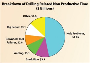
Figure 1 shows downhole tool-related problems contributed to $2.8 billion of the total drilling-related NPT. First-generation RTCs, which are an offshore/onshore interface, have contributed to lowering this part of the total NPT. Hole and stuck-pipe problems contributed to $18 billion of the total; the challenge now is to address this part of NPT to reduce total well cost.
RTCs need to evolve into centers where cross-discipline teams collaborate to solve drilling challenges, such as stuck pipe or hole problems, in addition to reducing service-quality issues. These teams need to work together through integrated workflows that allow all available data to be used to make better decisions. Further, results must be continuously optimized.
Three workflows that can be used today to help reduce NPT and place the well in the right spot are a digital consulting and collaborative well planning workflow, a digital drilling workflow and a digital geosteering workflow.
Collaborative Well Planning
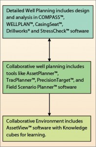
The end product of collaborative well planning is the field development plan. After well plans have been developed, they can be validated for torque and drag, anti-collision and other design considerations through use of applications software. Figure 3 illustrates this workflow. For a field development plan where hundreds of wells are needed, footage drilled and pad locations can also be optimized to hit the maximum number of targets.
The rough field plans are then individually analyzed for detailed anti-collision issues. Analyses for torque and drag, hydraulics, pore pressure and tubing are performed. The results can be presented as a 3D view.
Planning in Utah
The Natural Buttes field in Utah has marginal economics. After encountering a collision and difficulty planning the lazy S-shape of the wells and hitting multiple targets, the operator looked for another solution. One complication was that pads could not be located within 150 ft of endangered cactuses in the area. Due to pad drilling and close spacing, changes to the plans after permitting slowed down the drilling process.
Halliburton Consulting used collaborative well planning to plan multiple scenarios and optimize existing pads, saving more than $30,000/well. If the operator had continued to drill the whole field with 7,000 wells, that would have been a savings of more than $200 million.
Planning in Pennsylvania
In Pennsylvania, well planning tools were used to quickly select locations in treacherous terrain for more than 400,000 acres, optimize the use of drilling slots within pads and increase lateral extent to hit more reservoir targets while reducing the number of pads. This resulted in savings of $45 million in pad construction and gained nearly 2 million ft of lateral length. More than 520 drilling days were saved, which reduced costs by more than $25 million.
Digital Drilling Workflow
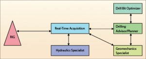
The digital drilling workflow is focused on optimizing wellbore stability. An operator can customize its own digital drilling workflow to focus on critical issues and challenges expected.

Figure 6 represents the workflow focused on the wellbore. Real-time data is streamed from the rig. A hydraulics specialist determines the real-time equivalent circulating density (ECD) from the incoming data and determines if the mud is in good condition. The specialist then provides the ECD information to the geomechanics specialist, who focuses on pore pressure, fracture gradient and wellbore stability issues. This helps the geomechanics specialist determine downhole conditions.
A bit specialist uses this information to determine the appropriate bit required. Choosing the wrong bit can cost an operator an extra trip, which could range from a few hundred dollars to hundreds of thousands of dollars depending on the location and well depth.
The drilling supervisor is responsible for keeping and updating the plan. His real-time input is provided by the hydraulics, geomechanics and bit specialists. The drilling supervisor compares the original plan from the collaborative well planning workflow with actual data and updates it with real-time parameters.

Workflow advantages
One of the main advantages of this drilling workflow is that it operates in a proactive manner and can optimize the wellbore. The drilling adviser can compare the plan with real-time values in order to change the well direction before any problems occur. All the models for torque and drag, pore pressure, etc, are inherited from the collaborative well planning phase.
Geosteering Workflow
The goal of geosteering the well is to optimize well placement in order to get the maximum reservoir contact. Figure 7 shows the geosteering workflow.
Operators define the target zones for the geosteering operation. These boundary limits or payzone geological layers are either obtained from offset wells or seismic data. The real value of the geosteering workflow comes into play when new geological surfaces and faults are identified in real time while drilling.
This new workflow provides the ability to move new faults and geological surfaces back to models and plans so they can be updated in real time and used for current or future well development. The operator can then view this new data and update the model while the geosteering engineer waits for new boundary instructions. By updating faults and surfaces in real time, operators can save time and better ensure optimal well placement.

Summary
Digitizing the oilfield is a concept of using digital resources in a shorter time frame as a result of extensive collaboration and use of new technologies and integration of product lines. The workflows discussed here are examples of such oilfield digitization.
The key to solving NPT challenges is contingent upon using specific workflows. Combining information from different services will help in overall performance and reliability and help to develop a new level of integrated operations. These workflows are independent of each other, enabling more flexibility and use of innovative technologies to address NPT challenges.
References
- “The original E&P Spending survey’’, Lehman Brother Equity Research 2008.
- “Combining Drilling and Evaluation Technology in Remote Operations Increases Reliability’’, Arve K. Thorsen, SPE, Elin Vargervik, SPE, and Vebjorn Nygaard, SPE, Baker Hughes.


