Exploration on the Atlantic Frontier has been hit-and-miss, but hope lingers for breakthrough
By Jeremy Cresswell, contributing editor
As IADC members know all too well, patience is a prerequisite for success in the petroleum industry; it’s a basic fact. But some energy provinces take a lot more figuring out than others before the door to the prize is unlocked.
A prime example is surely the Europe Union portion of the Atlantic Frontier, that is, the waters west of France, Ireland, Portugal and Scotland. While a number of promising finds have been made, especially west of Shetland – with three sizable developments producing successfully – and Irish results tantalise, the Bay of Biscay and Iberian waters have yet to yield a meaningful prize.
Take the French sector. Thirty years ago, high hopes on France’s Atlantic Shelf led to the drilling of 24 wells in the Gulf of Gasgogne, alas with no luck.
In 1995, there was renewed interest that resulted in the Antares discovery on the Bon Maritime permit (Bay of Biscay). But licence operator Elf declined to pursue it further because of poor reservoir quality, unacceptable oil prices and the high cost of extracting oil from such a remote location.
Then there was nothing for several years until, in July 2007, Canadian company Vermilion (a wholly owned offshoot of Verenex) came onto the stage by securing a licence with the French authorities to explore the Aquila permit in the Bay of Biscay.
The permit has an initial term of three years and provides the right to explore an area of 709 sq km adjacent to the eastern boundary of the Aquitaine Maritime offshore exploration permit, which was already held by the group but was due to expire in 2007. However, there is no evidence of this acreage having been relinquished.
In August 2007, Verenex spud its Orca-1 well on the neighbouring Aquitaine Maritime block following a 27.5% farm-out agreement with Bordeaux Energy, which had been reached in December 2006.
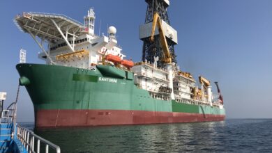
In the event, the $55-million well drilled by the semisubmersible Byford Dolphin was a duster. However, the well, with a planned TD of 2,850 m, did encounter a thick sandstone formation as indicated by seismic. The company said in a brief statement that further evaluation of the data gathered from this well, together with integration of this data with 3D seismic, would provide a better understanding of any potential of the remaining undrilled structures on the Aquitaine Maritime permit.
Meanwhile, Hunt Oil was noted in late 2007 as being in talks with the French authorities with a view to acquiring a significant parcel of acreage in the vicinity of the Aquila and Aquitaine Maritime licences. However, the company has kept a low profile regarding this.
The hydrocarbons experience offshore Portugal has been even more disappointing, and the first relevant licensing about six years ago yielded a very muted response.
That said, it is believed that offshore deposits do exist, given Spain’s experience with the Gulf of Cadiz Basin fields Poseidon Norte and Sur, where gas has been successfully produced from Messinian turbidite sands.
Repsol YPF and partner RWE-Dea talked of utilizing this proven Tortonian-Messinian sedimentary model and extrapolate westwards into the Algarve basin in Portuguese waters.
They were the only companies to table bids in that first Portuguese deepwater round, which was staged late 2002. The duo applied for and were awarded blocks 13 and 14, since when the trail has gone cold, with no discernible activity.
Twenty companies had expressed interest in bidding on one or more of the 14 blocks on offer by the Portuguese Instituto Geológico e Mineiro (IGM).
It had been expected that block 14 would attract several bids because of its location, close to the small (60 bcf), shallow Poseidon gas field operated by Repsol in Spanish waters.
Of the 14 Portuguese blocks offered, four were in the Estremadura/South Peniche area, six in Alentejo/Sagres and four in the Algarve Basin. Geologically, the acreage lies in an area that is considered analogous to those oil-producing areas of West Africa and Eastern Canada.
Today, it would appear that the Portuguese sector is moribund. Even in an industry as good at keeping secrets as petroleum, some news would have trickled out over the five years since these licences were issued.
In sharp contrast, the Irish slice of the Atlantic Frontier appears to be coming alive, witness one of the world’s premier-league semis, the Leiv Eiriksson, starting to drill an appraisal well on the Dooish discovery of 2002, while on the same day (19 May 2008), StatoilHydro spud a well on the Cashel prospect (19/8-1) in the Erris Trough using the semi Ocean Vanguard.
However, Ireland has mostly been one of those places where promise is just around the corner … tantalizingly close yet so far away. This includes the offshore Corrib gas field development, which should have come on-stream in 2005 but remains stalled as a result of a long-running onshore planning dispute.
This heritage Enterprise Oil (Shell acquired the company in 2002) development literally became bogged down over a bog-related planning row during 2002. Since then, various attempts have been made to get Corrib back on track.
The field lies 70 km offshore; its reserves are some 880 bcf of gas, though the last appraisal well delivered a scare, with poor results. Corrib is important for Ireland as it would be the country’s second-ever offshore development, the first being Kinsale.
As for the Irish exploration effort, currently the closest frontier target in terms of a tangible result is Dooish, a discovery made in 2002. Much local speculation has been made concerning its size.
The 12/2-1z Rockall Basin well appeared to encounter a significant oil column, but Shell kept quiet. The Irish Department of Communications, Marine and Natural Resources said in October 2002 that a “substantial column of hydrocarbons” had been encountered.
So the semisubmersible Jack Bates returned in May 2003 to re-enter the well. While further hydrocarbons were found, Shell was guarded in its comments, saying that the well had not been tested.
Dooish is the second-deepest water depth in which a well has ever been drilled offshore Ireland. It sits midway between the Amoco-operated 12/13-1A duster of 1979 and the 2001 Errigal wildcat drilled by Enterprise on block 5/22, close to the maritime border with the UK. This well was completed as a tight hole after 34 days at a total depth of 4,070 m, since when nothing has been disclosed.
The last time StatoilHydro had a crack at drilling west of Ireland was in 2002. The target was the Cong prospect, which is located in the Erris Basin, 45 km northwest of Mayo. The well was to have been spud in late July and take just over two months to complete. Drilling started on 5 August, some 20 km northeast of Corrib. Early December saw StatoilHydro acknowledge the well was a duster, yet again dashing Irish hopes.
Cong lies 35 km to the northeast of Cashel, which may hold recoverable reserves in the order of 250 million bbl of oil equivalent.
The company had last drilled offshore Ireland on the Sarsfield prospect (35/21-1) in the Porcupine Basin in 2001. But it was a failure. Prior to that, in the late 1990s, StatoilHydro participated in the Connemara field appraisal programme. It was a disappointment too, though the Connemara field per se is back on the agenda as a development prospect. Another 2001 flop was the Samedan-operated 63/4-2 well drilled in the Fastnet Basin.
And that is one of the frustrating aspects of the Irish (and UK) sectors of the Atlantic Frontier – an arguably moderate number of wells drilled, but a low success rate.
Of the not-quite-130 exploration wells drilled in Irish waters so far, fewer than 40 have been drilled out west and, of these, 15 recorded hydrocarbon shows.
The main basins that collectively comprise the Irish Atlantic Frontier are Porcupine to the southwest, Slyne off the west coast, the Erris and Donegal Basins to the northwest and the distant ultra-deep water Rockall Basin, which stretches into the Atlantic to the west, as far as the Canadian border and abuts the UK aquatory.
A number of these finds are at the heart of the inventories of Irish companies Providence Resources and Island Oil & Gas.
First, Providence, whose assets include Spanish Point and Burren, Goban Spur, Drombeg and Dunquin.
Spanish Point: a gas/condensate find (IRL35/8-2) that was made by Phillips Petroleum in 1981. The discovery well test-flowed at some 1,000 bbl of oil and 5 million cu ft of gas per day. Post-drill analysis suggested that while the field could have contained recoverables of up to 1.1 tcf of gas and 112 million bbl of oil, it was deemed uneconomic at the time.
Providence has since re-run the numbers and come up with recoverables of 1.4 tcf and 160 million bbl of oil. Moreover, it may now be an economic proposition, and the company has since successfully attracted Challenger Minerals as a farm-inee.
Linked with Spanish Point is Burren (IRL35/8-1), a find that was made by Phillips Petroleum in 1978. The discovery well flowed good quality 34° API oil at some 700 bbl/day. It is likely that Burren will be packaged with Spanish Point for development.
Goban Spur: While Providence is the operator, it holds just 16% after deals that gave ExxonMobil 80% and Scottish company Sosina 4%. Licence 06/1 comprises 15 exploration blocks 300 km offshore southwest Ireland, in other words at the northernmost edge of Biscay.
The exploration potential of the Goban Spur Basin has only been tested by the Esso IRL62/7-1 well, which was drilled in 1982. As part of the work program, the partnership acquired 500 km of long offset 2D Seismic, gravity and magnetics over the area in 2006, which data is being analysed and integrated into a geological and geophysical review of the area.
Dunquin: This is where the big money is being bet, witness the farm-in deal with ExxonMobil late 2006, followed in March 2008 by ExxonMobil assuming operatorship of this potentially huge hydrocarbons deposit in the Porcupine Basin, and then itself offering farm-in opportunities via Indigopool.
Dunquin covers a huge area, spreading across Irish blocks 44/18, 44/23, 44/24, 44/29 and 44/30; seismic mapping over the area has suggested the presence of two significant carbonate plays – Dunquin North and South.
The Dunquin South and Dunquin North prospects cover areas of 48 sq km and 75 sq km, respectively, and both exhibit a minimum of 400 m of mapped structural closure. The prospects have been technically matured using a grid of 2D seismic data, including a 2006 proprietary survey and a reprocessed 1999 survey.
Both prospects are “technically mature and ready to be drilled.” The initial well, located in a water depth of approximately 1,700 m, will target the crestal part of one of the mapped structures. However, no site operations have been carried out to date.
Each is expected to be gas/condensate-bearing. If confirmed, the condensates dimension could prove of immense strategic value, perhaps even making the difference in terms of the viability of any hydrocarbon discoveries that might be made.
ExxonMobil estimates that Dunquin South has an unrisked mean recoverable volume of 4.4 tcf of gas and 160 million bbl of condensate and the Dunquin North prospect 4.0 tcf and 156 million bbl.
The corresponding estimated P10 volumes are 9.5 tcf of gas and 340 million bbl condensate (Dunquin South) and 8.6 tcf and 322 million bbl.
There are no outstanding material commitments under this licence. However, it is pointed out by ExxonMobil that, in order to maintain the licence into the second phase (starting 15 November 2008), the licensees must propose the drilling of an exploration well by 14 August 2008, which suggests drilling could happen as early as 2009.
Linked with Dunquin is a licence award made in March 2008 covering 13 adjacent blocks, including the Drombeg Prospect, which will be extensively mapped first using long offset 2D before deciding any future course of action.
Prior to spudding the Dooish well, the Leiv Eiriksson had been working for Shell, drilling the South Uist Prospect on UKCS Block 214/21a in the Faroe-Shetland Channel, which brings us to the British part of the Frontier.
For Unst, geotechnical data had anticipated that there was an 18% chance of hydrocarbon discovery being made and that the target most likely contained dry gas/gas condensate. This prospect is located on block 214/21a and lies north of the Torridon gas discovery and east of the Rosebank/Lochnagar oil find.
In characteristic style, having drilled the well and sent the Leiv Eiriksson on its way to Dooish, Shell then classified South Unst as a tight hole.
Likewise, Hess said nothing about the outcome of its 2008 appraisal sidetrack, 204/25a-8Y, on the Schiehallion attic oil prospect, Amos. BP-operated Schiehallion is one of the backbone producing fields west of Shetland and could become the subject of redevelopment as this heavy crude field and its satellites are more prolific than originally supposed. The other core UK West of Shetland producing fields are Foinaven and Clair Phase-1, with Clair Phase-2 under evaluation.
But it has been a more than 35 years haul to get to today’s position. In March 2008, Nick Loizou of the UK’s Department of Business, Enterprise and Regulatory Reform (BERR) told a Petroleum Exploration Society of Great Britain (PESGB) gathering that, of the 141 exploration wells drilled on the UK Atlantic Frontier to that point, only 22% could be classed as “successful,” though 33 encountered “notable” hydrocarbons.
It was pointed out that many prospective blocks had never been drilled and that “there is a great deal of very promising exploration potential on both licensed and unlicensed acreage.” He also said that, not so long ago, there was a commonly held “myth” that West of Shetland had limited hydrocarbon potential. But he asked on what was this myth based.
In his view, the myth was partly founded on the relatively low success rate, but, in reality, it mainly reflected the lack of knowledge and geologic understanding of the area.
Mr Loizou observed that, following the Laggan gas discovery in 1986, there were 17 failed exploration wells drilled on a similar play type. So was Laggan just an isolated mythological accumulation?
Not according to Mr Loizou, who has made something of a speciality of the UK Atlantic Frontier. He said the majority of the dry holes tested invalid traps.
The corollary of this is that analysis has demonstrated a high success rate for wells positioned on valid traps to be greater than 40%.
Reinforcing Mr Loizou’s thesis, in 2007, the significant Tormore gas discovery was made in the block adjacent to Laggan and may provide critical mass to enable development of the latter to proceed. Operator TOTAL’s dream is to create a West of Shetland gas hub, into which a network of fields can be tied, including those with associated gas.
Consider UK independents Chrysaor and Faroe Petroleum, both of which want to drill critical appraisal wells this summer that could, if successful, lead to two new developments, Solan and Freya.
Chrysaor has already booked a rig, the Byford Dolphin, to drill Solan this summer. Faroe, however, may fail to secure a rig this year. Seonaid, Clair field analogue, has a 100 million-plus bbl potential, compared with 30 million or so for Solan.
Both discoveries were shelved years ago as non-viable by their original operators and later relinquished. That said, the company that found Solan and deeper sister Strathmore on block 205/26a, Hess, tried to find a solution through the UK’s short-lived Satellite Accelerator initiative of the early 2000s.
As for Faroe, the company had hoped to drill Freya in summer 2005, but then wasn’t ready. The field lies just 10 km northwest of BP-operated Clair on block 206/10 in 460 ft of water. The 206/10-1 probe that identified the reservoir was drilled in 1984 by Mobil; a 140-m column oil-bearing sands was encountered, apparently with significant volumes in place. The ratio of gas to oil is thought to be low, which is considered good.
The 2008 appraisal, if it goes ahead, will likely involve a drill stem test. If this proves encouraging, then Faroe advises an extended well test is likely. This is in essence what BP did as part of the protracted process of building a commercial case around Clair.
It is thought that Freya has in place reserves in the range 100-500 million bbl. It is a candidate for standalone and Clair tie-in development options.
What matters is that Chevron has embarked on development concept studies, evaluating the options that basically distill down to a floating production unit and a suite of subsea wells. A FPSO is the most likely option, as ship specialist BW Offshore has carried out work on the project.
It was in late 2004 that Chevron, with Statoil, OMV and DONG as partners, made the Rosebank/Lochnagar discovery on UK block 213/27. Well 213/27-1z drilled the crest of a large anti-clinal structure named Rosebank. Two oil and gas accumulations were encountered with that well, since when a patient appraisal programme has been ongoing.
During a production test of the second of three planned appraisal wells in July 2007, the well flowed at choked rates of 6,000 bbl/day. The 205/1-1 well is located at the southern end of the Rosebank structure and was drilled to a vertical depth of just over 9,000 ft.
Rather than plough headlong into a development project, which had been widely expected, Chevron has opted for further appraisal and exploratory drilling of the wider Rosebank/Lochnagar acreage over the next three years, starting with Rosebank North in Q3 2008 using the drillship Stena Carron.
Chevron says the exact timing and location of these wells of these further wells has not been finalized as they are contingent upon results.
The oil that was found in the 205/1-1 well was very light, with a gravity of 38° API. North Sea oil is normally of 20-30° API quality, and the Clair, Foinaven and Schiehallion fields are around 25° API.
The very lightness of Rosebank/Lochnagar oil explodes another myth that has grown up around the UK’s Atlantic Frontier, namely that any oil found will be heavy.
To conclude this review, it is clear that much more exploration remains to be carried out before a comprehensive picture can be developed regarding the extent of hydrocarbon resources on the EU Atlantic Frontier. It is one thing modeling the region, but, as has so often been the case, it takes the drill bit to reveal what’s really going on deep down.